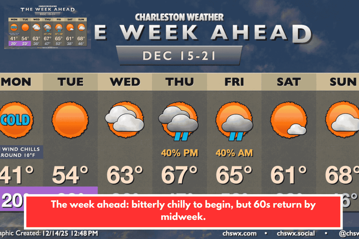
A potent Arctic air mass is delivering the well-advertised cold snap to the South Carolina Lowcountry, including Charleston. Morning lows near 20°F combined with north winds of 10-15 mph are pushing wind chills into the teens, possibly dipping below 10°F briefly. A Cold Weather Advisory remains in effect until 10 AM Monday—expect highs barely reaching 40°F under mostly sunny skies, feeling like the mid-30s due to lingering breezes.
Extended Forecast
- Monday Night/Tuesday: Freezing temperatures return after sunset, with morning lows in the 20s. Lighter winds ease chills, but another hard freeze looms. Southwest winds moderate highs to the low 50s by afternoon—still below seasonal norms.
- Wednesday: Mid-30s mornings warm to low 60s afternoons under increasing clouds.
- Thursday/Friday: A weak front brings a slight chance of showers Thursday, but milder air follows with mid-60s highs both days.
- Weekend: Brief cooldown Saturday, then rebound to near 70° Sunday ahead of the next front. Models differ on rain chances, so stay tuned—key for holiday shopping.
Cold Weather Safety Tips for Lowcountry Residents
Protect against the freeze with these practical steps, tailored to SC’s coastal vulnerabilities like salt marshes and urban pipes:
- People: Layer clothing (moisture-wicking base, insulating mid-layer, windproof outer). Limit outdoor time for kids/elderly; check on neighbors via Charleston County alerts.
- Pets: Bring them indoors if possible; provide unfrozen water and insulated shelters if outside.
- Pipes: Drip faucets, insulate exposed lines (common in older Charleston homes), and open cabinets under sinks.
- Plants: Cover tender vegetation or move potted plants inside—frost could hit gardens hard after recent mild weather.
- Vehicles/Home: Clear ice from windshields; use space heaters safely (never unattended). SC Emergency Management urges battery checks for power outages.
Monitor NWS Charleston updates or local apps like WCSC Live 5 for real-time wind chill maps. With Christmas nearing, bundle up for errands—local spots like King Street might feel extra brisk.
Stay safe out there—how’s your home prepped for the freeze?