Coastal Empire & Lowcountry, S.C. – A developing low-pressure system over Florida is expected to bring significant rain, strong wind gusts, and potentially tropical conditions to the region from Wednesday through Friday.
Overview of the System
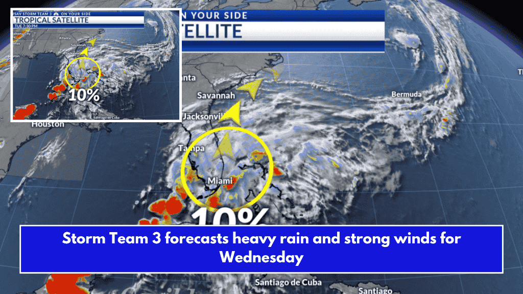
The low-pressure system, which previously caused heavy rain and strong storms last week, stalled out over Florida and is now forecast to become better organized. As it moves northeastward over the next few days, the National Hurricane Center is monitoring the system for possible tropical development once it reaches the Gulf Stream. While the likelihood of tropical development remains low, heavy rain and breezy conditions are expected to affect the area regardless.
Local Impacts
Rain and storms will begin moving into the region Wednesday morning, around sunrise, and continue through the day. Multiple rounds of rain and storms are anticipated throughout Wednesday afternoon and evening.
Strong wind gusts, particularly along the coast, could exceed 25 mph at times. These gusty winds, combined with heavy rain, will lead to potentially dangerous conditions. Some periods of intense rain and storms are also possible overnight and into Thursday morning, as the system moves just off the coast of Georgia and South Carolina.
Rain and storms will persist throughout Thursday, with more rounds expected on and off. Scattered showers will continue into Friday but should taper off as the storm moves further northeast, away from the region.
Rainfall Expectations
Rainfall totals will vary across the region. Coastal areas are expected to receive heavy rain, with totals possibly exceeding 2-3 inches. In contrast, western locations will likely see much lower amounts, around 0.5 to 2 inches.
Rip Currents and High Surf Risk
In addition to rain and winds, the system will also cause rip currents and high surf along the coast. Seas of 4-5 feet are expected, so extra caution is advised for anyone heading to near-shore waters in Georgia and South Carolina.
Weekend Outlook
By the weekend, a quieter weather pattern is expected to set up, with only a few passing showers or storms. High temperatures will return to the lower 90s.