Charleston is in for another hot and humid day this Friday before a cold front moves in over the weekend. After Thursday’s First Alert Weather Day, temperatures will remain high overnight, with humidity making it feel even warmer.
Hot and Humid Conditions Overnight
Thursday night will stay unusually warm, with temperatures staying in the upper 70s to lower 80s—close to breaking nighttime heat records. Some scattered showers and storms may pop up during the night, especially from the west. However, the risk of flooding remains low, and most of the rain is expected to clear out before Friday morning.
Friday: Heat Advisory in Place
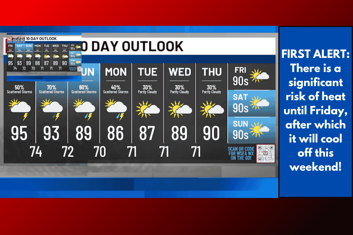
Heat Advisories are back for Charleston, coastal Colleton, and tidal Berkeley counties on Friday. The heat index—the “feels like” temperature—could go as high as 108 to 112 degrees by midday. Temperatures inland are expected to reach the mid to upper 90s, while coastal areas will see slightly cooler highs in the lower 90s.
Weekend Cold Front to Bring Rain and Cooler Temperatures
Relief from the heat is expected this weekend. A cold front will start pushing into the area by late Friday afternoon, bringing chances of widespread rain and storms, especially Friday night into Saturday.
Rainfall amounts could total between 2 to 4 inches by Monday, with even more in spots that get repeated storms. This could lead to localised flooding and water collecting on roads, so drivers should be extra careful.
Temperatures to Drop Over the Weekend
Saturday and Sunday will feel cooler compared to the past few days. Afternoon highs will only reach the low to mid 80s, which is 5 to 10 degrees below the usual temperatures for early August. Though it will still be humid, the drop in temperature will be a welcome change.
Detailed Daily Forecast
Tonight: Cloudy at times with a few isolated showers or storms. Low of around 77°C.
Friday: Partly cloudy skies with scattered rain or storms in the afternoon. High around 96°C, Low near 76°C.
Saturday: A mix of sun and clouds with scattered showers and storms. Cooler temperatures with a high of 85°C and a low of 72°C.
Sunday: Breezy with sun and clouds. Scattered rain or storms expected. High of 83°C and low of 73°C.
Charleston residents should prepare for extreme heat on Friday, followed by a wet and cooler weekend. The heat index could reach dangerous levels, so staying indoors during peak afternoon hours is wise. The incoming cold front will bring welcome relief from the high temperatures, but also a risk of heavy rain and localised flooding. Keep an umbrella handy and stay weather-aware over the weekend.