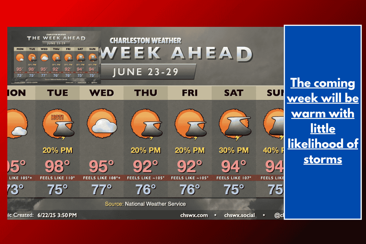
This week, heat will be the major weather story across much of the Eastern Seaboard, with the first part of the week bringing intense temperatures. A strong high-pressure system will keep the region under the influence of hot and dry air, leading to several consecutive days of high temperatures, including a stretch of 90°+ highs.
The Start of the Week: A Continued Heatwave
Monday will kick off a week of extreme heat, with temperatures starting in the low to mid-70s in the morning and soaring into the mid-90s by the afternoon. Expect mostly sunny skies as high pressure suppresses any cloud or thunderstorm development. Heat indices will climb into the range of 105-106° in the afternoon, particularly after the seabreeze kicks in.
Tuesday: The Hottest Day of the Week
Tuesday looks set to be the peak of the heat, with lows in the mid-70s inland and around 80° at the coast. By the afternoon, highs will reach the upper 90s, and a few spots might even hit 100°. Regardless of the exact temperature, the heat index will make it feel like triple digits, possibly pushing towards 110°. This will likely be the first heat advisory of the year, with heat indices expected to fall between 108° to 112°. A brief thunderstorm along the seabreeze might offer some temporary relief, but it’s unlikely to bring any significant cool-downs.
Midweek: Slight Break, but Still Hot
As we move into the middle of the week, the high-pressure system will weaken slightly, but it won’t provide much relief. Wednesday will see highs in the mid-90s, and heat indices may again approach advisory criteria. With high pressure lingering, the intense heat will continue to dominate, though conditions should remain mostly dry.
Toward the Weekend: Increased Humidity and Afternoon Storms
By the weekend, the high-pressure system will continue to weaken, allowing more humid air to move into the region. This will increase the chances for afternoon thunderstorms each day, but temperatures will remain hot, with highs still reaching into the low 90s. Away from any storms, heat indices will remain in the mid-to-upper 100s.
Key Points to Remember:
Expect 90°+ highs for nine consecutive days.
Heat indices could approach 110° on Tuesday.
Heat advisories are possible starting Tuesday due to high heat indices.
The second half of the week brings more humidity and a chance for afternoon thunderstorms.
Make sure to take precautions during this intense heatwave by staying hydrated, limiting outdoor activity during peak heat, and keeping an eye on local advisories.