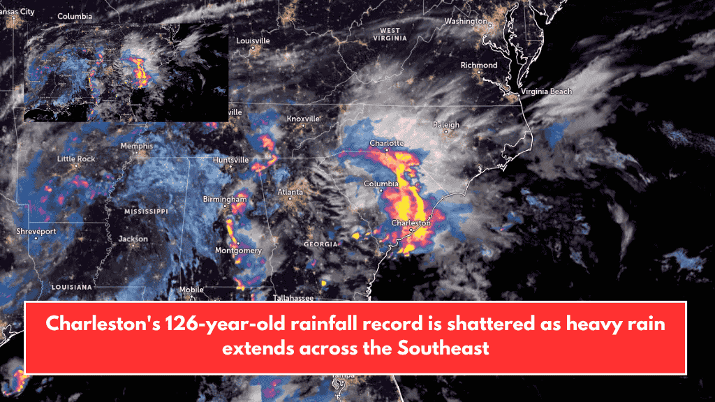
On Sunday, May 11, 2025, Charleston, South Carolina, experienced record-breaking rainfall as a slow-moving, moisture-heavy storm swept across the Southeast and mid-Atlantic regions. The storm caused flash flooding, travel disruptions, and raised alerts for ongoing flood threats into midweek. The National Weather Service (NWS) and Weather Prediction Center (WPC) have continued to issue warnings, urging residents to stay alert.
New Rainfall Records in Charleston
Charleston International Airport recorded 50.5 mm (1.99 inches) of rain on May 11, surpassing the previous record of 49 mm (1.93 inches) set in 1952. Meanwhile, downtown Charleston received an even higher total of 52.3 mm (2.06 inches), breaking a rain record from 1899 that stood for 126 years.
This intense downpour led to flash floods that submerged roads and stranded vehicles throughout the city. Local authorities and the NWS quickly issued flash flood warnings, reminding residents not to travel on flooded roads.
Wider Impact Across the Southeast
The storm didn’t only affect Charleston. In Florida, particularly at the Northwest Florida Beaches International Airport in Panama City, 19.05 mm (0.75 inches) of rain fell within just eight minutes during the early morning hours of May 11. That’s equivalent to an extreme rainfall rate of 143 mm (5.63 inches) per hour. In just two hours, the total rain reached 57.4 mm (2.26 inches), showing how intense this weather system has been.
Flood Risk Continues Into the Week
The WPC has forecasted continued heavy rainfall and thunderstorms in the Southeast and mid-Atlantic through at least Wednesday, May 14. Flash flood risks remain high, especially in densely populated or low-lying areas.
Southeast Florida, including major metro areas, has been placed under a Moderate Risk (level 3 of 4) for heavy rain. A Marginal Risk (level 1 of 4) reaches into the Ozarks and Middle Mississippi Valley. From Virginia down through the Carolinas and into parts of Florida, a Slight Risk (level 2 of 4) for excessive rainfall continues through Monday.
On Tuesday, May 13, the storm is expected to shift toward the Ohio and Tennessee Valleys, bringing heavy rainfall to the mid-Atlantic. Flood risks will stretch from the southern Appalachians to the upper Ohio Valley.
Heaviest Rain Expected in the Blue Ridge Region
One of the areas expected to receive the most rainfall is the Blue Ridge Mountains of North Carolina and Virginia. With southeasterly winds enhancing rain over the higher elevations, totals between 76 to 127 mm (3 to 5 inches) are expected, with some spots possibly receiving up to 178 mm (7 inches).
Nearby, the Virginia Piedmont may also see significant rainfall ranging from 51 to 102 mm (2 to 4 inches) through early Wednesday.
Western U.S. Sees a Different Weather Shift
While the Southeast deals with rain and floods, the Western U.S. will experience a cooling trend with an approaching storm. The Pacific Northwest will see widespread showers and snowfall at higher elevations, particularly in the Northern Rockies. By Tuesday, this system will extend across the western third of the country, bringing cooler temperatures and a break from the early-season heat.
Charleston’s new rainfall record on May 11, 2025, is just one example of the widespread impact of this major storm system sweeping across the U.S. Southeast and mid-Atlantic. As rain continues through midweek, flash flooding remains a serious threat, particularly in the Blue Ridge Mountains and surrounding areas. Residents are urged to stay informed through weather alerts and avoid travel in flood-prone zones. The next few days will be critical for monitoring conditions and ensuring safety.