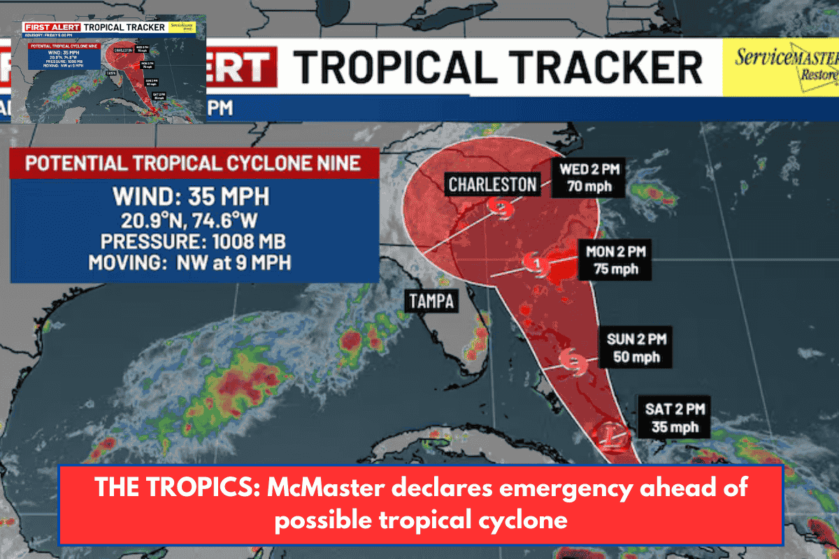
Charleston, South Carolina – Gov. Henry McMaster declared a state of emergency Friday afternoon as the state braces for the impact of tropical weather.
The National Weather Service reclassified Invest 94L as Potential Tropical Cyclone Nine.
The most recent projected path directs the system toward the Lowcountry coast.
It is expected to become Tropical Storm Imelda by Sunday, and it may briefly strengthen into a Category 1 hurricane before making landfall on Wednesday.
The storm’s current position
At 5 p.m. on Friday, the disturbance was centered near latitude 20.9 north and longitude 74.6 west.
The system is moving northwest at approximately 9 mph. Over the next few days, a north-northwestward motion is expected.
According to the forecast, the system’s center will cross the central and northwestern Bahamas this weekend before approaching the southeast coast of the United States early next week.
Maximum sustained winds are around 35 mph, with higher gusts.
The system is expected to gradually strengthen, becoming a tropical depression on Saturday and then a tropical storm Saturday night or early Sunday.
Based on surface observations, the minimum central pressure is estimated to be 1008 mb (29.77 inches).
The governor’s state of emergency declaration activates the South Carolina Emergency Operations Plan and directs the South Carolina Emergency Management Division to initiate statewide preparation and coordination procedures with all relevant local, state, and federal agencies prior to the landfall of a potential Tropical Storm or Hurricane. It also makes state and local emergency management agencies eligible for FEMA reimbursement for storm-related expenses.
“As this storm approaches our coast, I am issuing a State of Emergency to ensure Team South Carolina is able to access and deploy the resources and personnel needed to prepare for and respond to this storm,” Mr. McMaster stated. “While the storm’s arrival, speed, and intensity are difficult to forecast, we do know that it will bring significant wind, heavy rainfall, and flooding to the entire state of South Carolina. We’ve seen this before. Now is the time to pay attention to official forecasts, updates, and alerts and begin preparing.”
The Live 5 Weather team declared Monday and Tuesday First Alert Weather Days due to the possibility of rain and flooding from the system.
As a developing system in the Atlantic is expected to affect Lowcountry weather early next week, leaders are taking precautions to prepare.
City of Charleston
Charleston City Council held an emergency meeting on Friday afternoon to discuss the potential effects of an unnamed system that is expected to become Tropical Storm Imelda. Forecasts are pointing the system toward the South Carolina coast, but there is still disagreement about the storm’s exact path and strength when it makes landfall.
Council members met to discuss plans and protocols for dealing with tropical weather. Since Thursday, all city departments have been made aware of the potential effects.
City officials have deployed stormwater pumps, and Charleston Police have confirmed that barricades have been deployed. The Charleston Fire Department will have high-water vehicles ready. The city’s Public Works Department is developing a sandbag plan.
The city has lowered lake levels to prevent flooding ahead of the anticipated rain.
“Uncertainty doesn’t mean don’t prepare,” said Charleston Deputy Fire Chief Mike Julazadeh. “We need to think about emergency kits, what we might find in our hurricane guides on Charleston County and Berkeley County, South Carolina websites, and also know our zones. For example, the city and downtown are in Zone B, while West Ashley is in Zone C. So we should be familiar with our zones in case we have to evacuate.”
“Now is the time to prepare. “Get your house in order, get gas, get cash, get your boats off the water, and do all of the necessary things in the event that we have significant impacts on our area,” Charleston County’s Director of Emergency Management, Justice Pierce, stated. “What we do know is that once these storms start to pass through the islands, they’re going to have a chance that they’ll start to rapidly intensify, which means our preparedness window is going to start to shrink in terms of getting ready for this storm.”
North Charleston
All City of North Charleston offices will operate as usual until further notice, but city officials say this is likely to change based on storm forecasts.
North Charleston sanitation services will continue as planned unless otherwise notified. However, city officials asked residents to avoid putting yard debris and household items curbside until after the storm.
The North Charleston Public Works Department and its support staff are actively clearing drains, ditches, and low-lying areas ahead of the approaching tropical system. Staff remains ready to respond quickly as conditions change.
The city’s Municipal Court will be closed from Monday to Tuesday. However, bond hearings will be held daily. Individuals with scheduled court dates will be notified via mail of their rescheduled dates.
All recreational, cultural arts, and senior center programs and activities, including athletics, are canceled from Saturday to Tuesday. Athletic Buildings, Community Centers, and Senior Centers will remain closed until Tuesday.
Charleston County
The Charleston County Council declared a state of emergency Friday afternoon.
The primary threat to Charleston County is expected to be heavy rain and strong winds, which could arrive as early as Monday morning, according to a county release.
The county’s Emergency Management officials will maintain close contact with the National Weather Service throughout the weekend.
At this time, no operational changes have been announced, and Charleston County remains at OPCON 3.
Berkeley County
Berkeley County Emergency Management officials are monitoring the system’s potential for heavy rain over the weekend.
Berkeley County Roads and Bridges crews are inspecting flood-prone areas, storm drains, and culverts across the county ahead of the storm.
The County’s Emergency Operations Center is currently at OPCON 3 (normal operating conditions).
Georgetown County
Georgetown County declared a State of Emergency Friday afternoon and announced that its Emergency Management Department would be elevated to OPCON 2 at 10 a.m. Saturday.
OPCON 2 marks a “enhanced state of readiness,” as the county begins to actively implement emergency operations plans and coordinate more closely with local, state, and federal partners.
“By moving to OPCON 2, we are taking proactive steps to ensure Georgetown County is prepared to respond if this system has an impact on our area,” Georgetown County Emergency Services Director Brandon Ellis said. “While it is still too soon to know the exact path and strength of the storm, this change positions us to act quickly if conditions worsen.”